


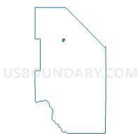
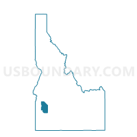
Voting District 53, Ada County, Idaho
About
Outline

Summary
| Unique Area Identifier | 563540 |
| Name | Voting District 53 |
| County | Ada County |
| State | Idaho |
| Area (square miles) | 0.69 |
| Land Area (square miles) | 0.69 |
| Water Area (square miles) | 0.00 |
| % of Land Area | 99.86 |
| % of Water Area | 0.14 |
| Latitude of the Internal Point | 43.62915850 |
| Longtitude of the Internal Point | -116.29795470 |
Maps

Graphs
Select a template below for downloading or customizing gragh for Voting District 53, Ada County, Idaho


Neighbors
Neighoring Voting District (by Name) Neighboring Voting District on the Map
- Voting District 30, Ada County, ID
- Voting District 31, Ada County, ID
- Voting District 51, Ada County, ID
- Voting District 52, Ada County, ID
- Voting District 54, Ada County, ID
- Voting District 65, Ada County, ID
- Voting District 66, Ada County, ID
Top 10 Neighboring County Subdivision (by Population) Neighboring County Subdivision on the Map
Top 10 Neighboring Place (by Population) Neighboring Place on the Map
Top 10 Neighboring Unified School District (by Population) Neighboring Unified School District on the Map
- Boise City Independent School District 1, ID (184,995)
- Meridian Joint School District 2, ID (184,676)
Top 10 Neighboring State Legislative District Lower Chamber (by Population) Neighboring State Legislative District Lower Chamber on the Map
Top 10 Neighboring State Legislative District Upper Chamber (by Population) Neighboring State Legislative District Upper Chamber on the Map
Top 10 Neighboring 111th Congressional District (by Population) Neighboring 111th Congressional District on the Map
Top 10 Neighboring Census Tract (by Population) Neighboring Census Tract on the Map
- Census Tract 23.02, Ada County, ID (7,852)
- Census Tract 24.10, Ada County, ID (7,051)
- Census Tract 23.12, Ada County, ID (5,278)
- Census Tract 24.11, Ada County, ID (5,269)
- Census Tract 23.13, Ada County, ID (3,993)